
About the project
Funded by Natural England’s Countryside Stewardship scheme and working with Wessex Rivers Trust, the Isle of Wight Council and the Environment Agency, Hampshire and Isle of Wight Wildlife Trust developed a capital works plan to re-naturalise the Eastern Yar floodplain to improve degraded and damaged wetland habitats and promote biodiversity.
The project required detailed design working with specialist consultants Wessex Rivers, consenting from Natural England, ordinary watercourse consent from Isle of Wight Planning and a Flood Risk Activity Permit from the Environment Agency.
In its natural state, a floodplain system is a dynamic landscape where water is abundant in multiple channels, pools and scrapes. This dynamism and wetness provide diversity and structure for a vast array of flora and fauna.
The Eastern Yar River Restoration plan (Isle of Wight Council, Arup, 2015) outlined several issues throughout the catchment, described as “heavily modified as a result of channel straightening, dredging, bed lowering, modification of banks and land use changes”.
The Eastern Yar is a system that has been heavily modified and is essentially functioning as a drain rather than a river. The management has historically prioritised conveyance of water away from land as quickly as possible. Decades of dredging and channel straightening have created a system that can no longer cope with modern climate or inputs into the system. Given the size and scale of the catchment and the water entering the system, it has created significant challenges for both people and wildlife.
Run off into the system is vast and increasing from urbanisation, intensive land use, road run off, hydrological changes in the upper catchment and changing weather patterns. The straightened channels, perched banks (from decades of dredging), have effectively cut the river off from the flood plain resulting in water moving at high velocity through the system until it reaches an impoundment such as a road bridge or culvert. These become rapidly overwhelmed and flooding occurs.
The main issues identified were:
- Sediment inputs
- Siltation
- Channel incision
- Lack of habitat diversity
- Lack of floodplain connectivity
Project aims
The project aims were to restore natural processes within the floodplain allowing a better functioning ecosystem; enabling increased flood storage capacity and deliver wetland habitat improvements on Trust land holding through the following actions
- Reprofiling of riverbanks to allow lateral movement of water, reconnecting the floodplain, allowing the conveyance of water onto the floodplain earlier in a flood event resulting in more time for downstream infrastructure to operate before it becomes overwhelmed.
- Increase flood storage capacity through facilitating the conveyance of water onto and off of the floodplain.
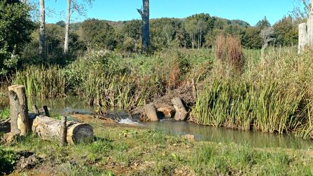
- Installation of woody debris to improve diversity within the channel and encourage meanders to develop to slow the flow of water, reducing velocity and erosion.
- Habitat restoration by removal of willow scrub in areas of degraded fen and reedbed.
Completed Project
This project was completed in Autumn 2025 with the following work carried out:
Early Stages and site preparation
Early discussions were held in 2023 with Natural England and the Environment Agency. We hosted several site visits to discuss plans and begin the process of sourcing funding and consents.
Throughout 2023 and 2024 we worked with Wessex Rivers Trust to finalise the details of the planned works. They produced all the technical drawings, calculations and information needed to complete the capital works.
Site preparations began in August 2024, this included moving livestock off site & removing sections of fencing, to ensure access for machinery. Thorough site surveys were carried out before machinery moved in to start scrub clearance work
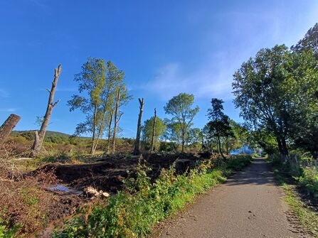
Scrub and tree works
During September 2024, contractors began scrub working on site at Newchurch, Lower Knighton Moor, and Sandown Meadows by removing willow scrub. Large poplar trees were then fell at Lower Knighton Moor. These trees were planed in the 1950s as a crop to be harvested for matchsticks but were not harvested. They shade out large sections of wetland habitat which could be better quality fen and reedbed. The trees were also beginning to show signs of instability due to age meaning potential for sudden tree fall of large limbs onto the public right of way. To further improve habitat biodiversity, 12 trees were felled and a further eight pollarded to reduce their height. Pollarded stems are ring-barked creating a much-overlooked habitat type – standing deadwood.

©Emma Hunt
©Emma Hunt
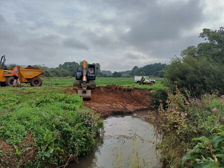
River Reprofiling
Also in September 2024, contractors began the river reprofiling work at Newchurch Moors. 300m of raised river bank (caused by historic dredging) was removed along the main channel through Newchurch Moors.
The spoil (excavated material) was then used to create a low bund (low earthen embankment) alongside the right of way. This will allow the pooling of water within the floodplain and reduce the severity of flooding on the right of way itself.
Additionally, two swales were cut to lower the bank further, allowing the river to spread laterally and utilise the floodplain sooner, thereby increasing flood water storage capacity and helping to develop wet grassland habitats with higher biodiversity than the current soft rush dominant grassland.
At Alverstone mead, over 200m of river bank was reprofiled. Along this 200m stretch the raised bank was up to 1.5m above the field level, meaning that the only connection to the floodplain was where the main channel overtopped at Alverstone road bridge and flowed into the site where water (and silt, debris and other river borne substances) would then be trapped on site for weeks at a time, further degrading the wet grassland habitats.
Additionally, a swale at Newchurch moors was excavated to allow even greater connectivity and flood water storage capacity. Dug spoil was used to partially infill two ditches: one to create a crossing point with a culvert and the other to shorten the length of a ditch. This will help in the movement of livestock around the site and better access for machinery to facilitate the restoration of biodiversity within the floodplain meadows.
©Emma Hunt
©Emma Hunt
The contractors then moved on to Sandown meadows, lowering the raised bank and cutting a swale in the channel in the Long Field, allowing the floodplain connection and increased flood water storage capacity.
An existing low spot in the field was further excavated to create a large scrape feature. The dug spoil was used to create a low bund along Golf Links road to reduce the impact of the seasonal flooding on the road. On the eastern side of Sandown Meadows the riverbank was reprofiled in two sections, totalling just over 200m, two swales were cut to allow floodplain connectivity.
In August 2025 work continued on site (having stopped the previous year due to adverse weather). During this period spoil from 2024 was tidied, a new meander section at Newchurch Moors was completed as well as the re-profiling of a swale causing a large build up of silt.
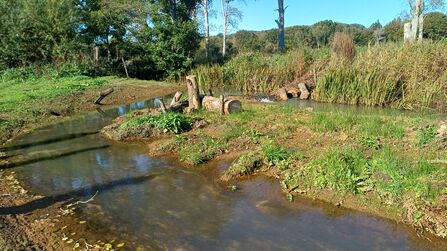
Throughout autumn, several areas of woody debris were installed across the sites the timber cut from the poplar trees in 2024. Large diameter timber was secured to the riverbed with vertical supports and added willow bundles to encourage some channel morphological processes to develop, raising the bed level in localised areas and encouraging scouring to uncover riverbed gravels in other areas.
Mid-sized diameter timber was installed horizontally into the river banks to encourage meanders to form and create varied channel depths, providing areas prone to siltation which will host marginal vegetation. We made use of existing natural features such as part-fallen trees and enhanced these, adding various sized of timber and willow bundles to create as great a diversity of habitat features as possible.
©Emma Hunt
At Alverstone mead, the old water control structure was replaced with a drop board sluice to give greater control over water levels on the meadow. The old structure was broken and no longer functioning as intended.
The area was dug out, a concrete headwall installed and aluminium boards provided to allow water to be held back (through spring and summer to keep the site wetter) or released (such as if machinery is going to be used to cut rush or ground conditions are wetter than optimal for grazing livestock).
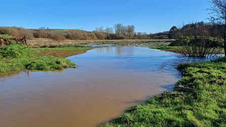
Results
Early indications suggest that the works have been successful in creating more wetland habitat and in restoring some of the degraded fen habitats back to a more biodiverse state. Anecdotal evidence from observations by Trust staff and volunteers suggests that rights of way and local roads are less impacted by flooding. This was corroborated by the Environment Agency with their gauging station at Alverstone triggering fewer flood warnings on average during rainfall events.
A conservative calculation of the amount of flood water storage across Newchurch, Alverstone and Sandown has been made at 155.000,000 litres of water, equivalent to 62 Olympic sized swimming pools.

©Emma Hunt
Climate
Heavy rainfall events are set to occur more often with climate change and when the land has been heavily modified flooding is the consequence. The run off into the system is vast, coming from developed land, agricultural land and roads.
The pressure on the Eastern Yar will continue to increase with changing climate and weather patterns. Much of the lower catchment is a former estuarine system and is below mean sea level meaning flooding will continue to be an issue. More needs to be done to capture water at source and restore natural function to mitigate the impacts of flooding.
During high rainfall events the system quickly becomes overwhelmed and flooding occurs. During winter 2025/26 the Island was hit with extremely high rainfall events:
- December 2025: 130.2mm of rain was recorded (opposed to the average rainfall of 99.9mm)
- January 2026: 182.8mm of rain was recorded (opposed to the average rainfall of 97.9mm - nearly doubling the average)
- February 2026: 175.2 mm of rain was recorded (opposed to the average rainfall of 71.9mm - over double the average. With 40mm falling in under 24hours on the 1st/2nd February)
This project isn't the whole solution, but is part of the solution however, more needs to be done within the catchment to restore natural functionality of the Eastern Yar.
The future
Silt will need to be monitored and likely removed by excavator, particularly in the swales to ensure they remain functional and that the scrapes and low-lying land doesn’t fully silt up. The sites and works provide a good visual example of the volume of silt in the eastern yar, and it does open the door for a wider-reaching conversation about preventing silt from entering the watercourses upstream.
There is scope to extend the application of the principles used in this project further throughout the catchment and on more of the Trust estate including nature reserves such as Morton Marsh. This could help further mitigate some of the flooding impacts whilst simultaneously providing benefits for wildlife and local communities.